


 Download Free Sample
 Buy Now
Market Forecast
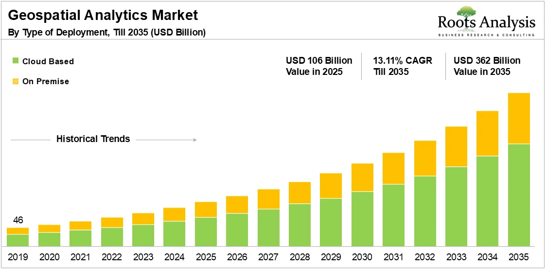
The global geospatial analytics market is projected to grow from USD 106 billion in 2025 to USD 362 billion by 2035, at a CAGR of 13.11% during 2025-2035. This strong trajectory is driven by the rising integration of geospatial technologies, including GIS, GPS, and remote sensing across multiple industries, such as defense, energy, transportation, and agriculture.
See What’s in the Full Report - Request Your Complimentary Insights!
Market Report: Key Takeaways
- In the past five years, more than 4,000 patents have been filed related to geospatial analytics; ~90% of these have been filed in the US, followed by WO-WIPO and European Patents, respectively.
- GIS remains the dominant technology, while remote sensing is the fastest-growing, supported by rapid advances in satellite imaging, drones, and AI-enabled feature detection.
- Cloud-based geospatial platforms hold the largest share, as enterprises prioritize scalable data processing, real-time analytics, and integration with ML/AI pipelines; on-premises remains essential for defense and classified workloads.
- Defense and Intelligence leads vertical adoption, given mission-critical needs for surveillance, mapping, and border monitoring, whereas logistics & supply chain is the fastest-growing due to e-commerce expansion and last-mile optimization.
- North America is the largest regional market, backed by strong institutional frameworks (USGS, NGA), while Asia-Pacific records the highest growth, supported by smart city programs, agricultural modernization, and government geospatial mandates.
- AI, machine learning, and IoT are reshaping the industry, enabling automated imagery interpretation, predictive modeling, and richer location-based insights, thereby significantly expanding enterprise use cases.
Market Overview
Geospatial analytics refers to the systematic gathering, interpretation, and visualization of spatial data tied to specific locations on Earth’s surface. It combines geographic information systems (GIS), global positioning systems (GPS), remote sensing, and big data analytics to provide insights into patterns, relationships, and trends.
In 2026, the technology is recognized as a core enabler of data-driven decision-making across industries. By integrating time, location, and context into traditional datasets, geospatial analytics supports critical applications ranging from urban planning and precision agriculture to defense intelligence, logistics optimization, and climate monitoring.
Modern organizations increasingly rely on cloud-based geospatial analytics platforms to manage massive, real-time data streams generated by IoT sensors, satellites, and drones. This shift has democratized spatial intelligence, making it accessible to small and medium enterprises in addition to government agencies and Fortune 500 corporations.
Notably, the market’s evolution is also being shaped by the expansion of 5G networks, AI-powered spatial modeling, and the emergence of digital twin ecosystems that simulate cities, supply chains, and environmental systems in virtual environments. These innovations are redefining how enterprises assess risk, optimize resource allocation, and forecast change.
As governments worldwide strengthen their sustainability and national-security frameworks, demand for geospatial technologies in environmental monitoring, border control, and emergency response is set to surge. Consequently, the geospatial analytics market outlook remains optimistic, with substantial opportunities for solution providers offering integrated, scalable, and real-time spatial analytics capabilities.
Recent Developments in Geospatial Analytics Market
Several recent developments have taken place in the market, some of which have been outlined below.
- In November 2025, Hexagon acquired a precision inertial / GNSS provider to tighten its geospatial sensor stack and improve high-accuracy positioning for mapping, defense, and survey workflows.
- In October 2025, Planet secured USD 12.8 million contract from the US National Geospatial-Intelligence Agency (NGA) to supply high-cadence satellite data to government and enterprise customers, strengthening near-real-time monitoring capacity
- In July 2025, the NGA awarded multiple delivery orders under its commercial GEOINT programs to expand access to commercial imagery and analytic products for government users.
- In July 2025, Esri unveiled major ArcGIS platform updates and AI-powered spatial tools at the Esri User Conference, boosting real-time analytics and low-code mapping workflows for enterprises.
- In July 2024, Trimble extended its strategic collaboration with Esri to forward advanced geographic information system technology and mapping capabilities. Through this partnership, companies aim to optimize infrastructure planning, construction, and operations with the help of data-driven decision-making.
- In February 2024, placer.ai entered a strategic partnership with Esri, (a leading GIS technology provider) to enhance customers' experience with better analytics capabilities.
- In January 2024, Deloitte unveiled a new geospatial and AI scenario planning and monitoring platform powered by Google Cloud.
Unlock Deeper Insights - Schedule Your Personalized Workshop Today!
Market Trends
The geospatial analytics market is undergoing rapid transformation as technologies like AI, IoT, and remote sensing converge with cloud computing and spatial modeling. Between 2026 and 2035, three major forces, technological innovation, data democratization, and real-time intelligence demand are redefining how organizations visualize and leverage location data.
Key Drivers Fueling Geospatial Analytics Market Growth
Rising Adoption of AI and Machine Learning for Predictive Spatial Intelligence
Artificial intelligence and machine learning have revolutionized geospatial data interpretation, enabling pattern recognition and anomaly detection at unprecedented scale. Leading players, such as Esri, Trimble, and Hexagon are integrating AI-driven geospatial platforms that automate feature extraction from satellite imagery and predict urban expansion, deforestation, or disaster impacts. For instance, Esri’s 2025 ArcGIS Pro update introduced deep learning-powered spatial modeling, enhancing precision for city planners and defense agencies.
Surge in Location-Based Services (LBS) and Real-Time Analytics
The global proliferation of 5G and IoT ecosystems is driving massive data generation through connected sensors and mobile devices. Retailers, logistics companies, and healthcare institutions now rely on geospatial analytics for asset tracking, route optimization, and customer engagement mapping.
Expansion of Smart Cities and Infrastructure Digitization
Governments in Asia-Pacific, Europe, and the Middle East are integrating geospatial technologies to manage urban planning, public safety, and energy optimization. India’s Smart Cities Mission 2.0 and Saudi Arabia’s NEOM project are major examples of public investments leveraging GIS and remote sensing to improve sustainability and citizen services.
Increased Use in Environmental and Disaster Management
Rising climate risks have made spatial intelligence indispensable for natural resource management, flood monitoring, and wildfire prevention. Agencies like NASA and the European Space Agency (ESA) are using AI-enhanced satellite analytics to track methane emissions, coastal erosion, and water scarcity trends.
Emerging Industry Trends in Geospatial Analytics
Integration of Digital Twins and 3D Geospatial Modeling
The adoption of digital twin technology is expanding, allowing governments and industries to simulate real-world systems from traffic networks to utility grids in 3D environments.
Cloud-Native and Edge Geospatial Platforms
Cloud deployment remains the dominant model, but edge-based geospatial analytics is emerging to enable low-latency data processing directly at sensor sites. Major providers like Microsoft Azure Maps and Amazon Location Service are scaling hybrid models that combine cloud flexibility with on-site responsiveness, especially for logistics and defense use cases.
Open-Source and Data Democratization Movement
Open-data initiatives and interoperable GIS standards are breaking entry barriers for SMEs and developers. The Open Geospatial Consortium (OGC) continues to push for transparent APIs, while startups like CARTO and MapLarge are using open frameworks to build accessible, low-cost analytics solutions.
Convergence with AIoT and Autonomous Mobility
Geospatial analytics is becoming central to autonomous systems, including drones and self-driving vehicles. For instance, HERE Technologies and TomTom International expanded real-time HD mapping services in 2025 to support AI-powered navigation and autonomous logistics.
Market Challenges in the Geospatial Analytics Industry
Data Privacy, Regulation, and Cybersecurity Risks
The massive collection of location-based data raises privacy and ethical concerns. Compliance with GDPR (Europe), CCPA (California), and upcoming India Digital Data Protection Act (2025) increases complexity for analytics providers handling sensitive geospatial information.
Lack of Skilled Professionals and High Integration Costs
Advanced geospatial systems demand expertise in data science, GIS, and AI integration, which remains limited globally.
Fragmented Data Ecosystems and Interoperability Issues
Disparate data formats, legacy infrastructure, and inconsistent metadata standards often hinder cross-platform geospatial collaboration. The push toward unified, API-driven ecosystems, such as OGC’s GeoPackage and Esri’s ArcGIS Hub is underway but still evolving.
Cost and Complexity in Real-Time Data Management
Processing terabytes of satellite imagery or IoT-generated spatial data in real time remains capital intensive. Although cloud platforms have reduced costs, the initial setup and ongoing maintenance of high-precision analytics systems continue to challenge smaller organizations.
See What’s in the Full Report - Request Your Complimentary Insights!
Market Segmentation Analysis
This section breaks the geospatial analytics market into actionable slices so readers can see where demand concentrates and why. Each sub-section gives the segment definition, the current dominance or momentum claim, and a short, strong rationale.
Market Share by Type of Component (Solutions vs Services): Which Segment Leads The Geospatial Analytics Market?
Market Insight: Solutions (platforms, packaged analytics) lead with ~62% of revenue in 2025. Services (consulting, deployment, managed services) make up the rest, with Deployment and Integration seeing the fastest services growth.
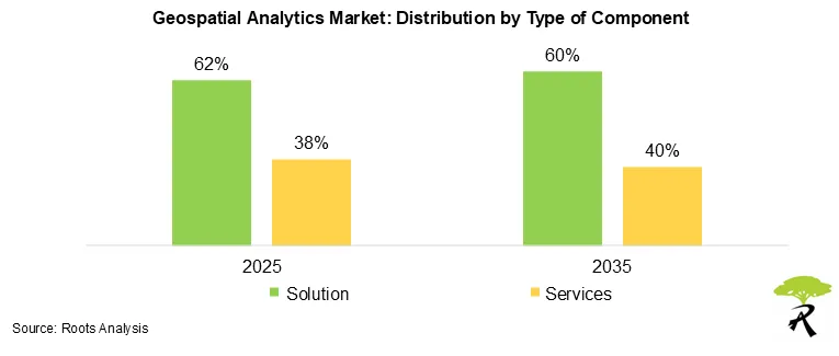
Market Validation: Companies buy end-to-end geospatial platforms to scale mapping, analytics and APIs across users and geographies. Solutions deliver recurring license or SaaS revenue and lower marginal costs. At the same time, complex enterprise rollouts, data pipelines and security needs drive demand for professional services (integration, customization, managed data ops).
Roots Recommendation: Companies should productize integrations and offer turnkey implementation bundles. Buyers should budget for integration and change management when selecting platforms.
Market Share by Type of Technology (GIS vs Remote Sensing vs GPS) Which Technology Dominates and Which Grows Fastest?
Market Insight: GIS leads at ~48% share today. Remote sensing posts the fastest growth (CAGR ~15.4%). GPS / positioning and LiDAR / point-cloud technologies account for the remainder.
Market Validation: GIS delivers core mapping, spatial joins and enterprise workflows; it remains mission critical. Remote sensing grows rapidly because private EO constellations, higher revisit rates, hyperspectral imagery and on-demand tasking increase imagery volumes and analytics demand.
Roots Recommendation: Combine strong GIS UX with plug-and-play remote-sensing analytics (change detection, crop indices) to win enterprise customers.
Market Share by Type of Deployment (Cloud vs On-Premises): Is Cloud Already Dominant?
Market Insight: Cloud-based deployments lead with ~67% share in 2025 and continue to gain share (cloud CAGR ~14.8%). On-premises retains a meaningful base (~33%).
Market Validation: Cloud offers faster time-to-value, easier collaboration, scalable compute for imagery processing, and SaaS pricing. Regulated buyers (defense, some utilities) still prefer on-prem for data sovereignty and control.
Roots Recommendation: Prioritize cloud-native product design and offer hardened on-prem or private-cloud options for regulated customers.
Market Share by Organization Size (Large Enterprises vs Small and Medium Enterprises): Who Buys Most and Who Grows Fastest?
Market insight: Large enterprises hold ~72% of current spend. SMEs are the fastest-growing cohort, with CAGR ~18.6% through 2035.
Market validation: Large institutions (defense, utilities, national mapping agencies) buy large contracts and custom integrations. SMEs adopt cloud SaaS, prebuilt dashboards and pay-as-you-go analytics as costs fall and templates appear.
Roots Recommendation: Maintain enterprise-grade features (security, SLAs) while packaging light, low-friction SME plans to capture the high-growth segment.
Market Share by Vertical: Which Industries Lead and Which Verticals will Grow Fastest?
Market Insight (Leader): Defense and Intelligence leads at ~19% share today.
Market Insight (Fastest Growth): Logistics & Supply Chain shows the highest growth momentum (CAGR ~16.9%).
Market Validation: Defense budgets prioritize persistent surveillance, secure geospatial platforms and national mapping. Logistics & supply chain demand rises from routing optimization, last-mile analytics, regulatory tracking and real-time visibility. Agriculture, energy, and utilities also show strong adoption for precision services.
Roots Recommendation: Build verticalized modules (secure modes for defense, routing stacks for logistics, crop analytics for agriculture) rather than one-size-fits-all products.
Your Business is Unique - Why Shouldn't Your Report Be?
Market Regional Insights
North America: Largest and Technologically Most Mature Market
North America remains the largest regional market, driven by advanced satellite programs, strong digital infrastructure, and deep enterprise adoption.
United States Geospatial Analytics Market
- The US leads the region, supported by established federal programs, such as USGS National Geospatial Program, the National Map, 3D Elevation Program (3DEP), and the National Geospatial-Intelligence Agency’s (NGA) GEOINT infrastructure.
- Broad enterprise adoption in defense, logistics, agriculture, utilities, and insurance reinforces demand.
- Cloud-first modernization across sectors accelerates use of geospatial APIs, remote-sensing analytics, and mobility data.
Canada Geospatial Analytics Market
Canada’s growth is powered by Geospatial Data Infrastructure (CGDI), major investments in environmental monitoring, and demand from forestry, mining, and smart-city programs.
Mexico & Other North American Countries Geospatial Analytics Market
Adoption is rising due to expanding urban planning, infrastructure development, and disaster-management modernization.
Europe: Strong Adoption Driven by Copernicus & Regulatory Frameworks
Europe is the second-largest market, characterized by high-precision mapping, environmental monitoring, and strong public-sector demand.
EU Countries (France, Germany, Spain, Italy, Nordics) Geospatial Analytics Market
- The Copernicus Earth Observation Program offers the world’s largest open geospatial data ecosystem, heavily used across energy, agriculture, climate analysis, and mobility.
- Strict data-governance, sustainability, and climate regulations drive enterprise use cases (carbon tracking, land monitoring, smart utilities).
United Kingdom Geospatial Analytics Market
The UK maintains strong geospatial capabilities through Ordnance Survey, transport analytics, and property / asset intelligence sectors.
Asia: Fastest-Growing Region (Smart Cities, Agriculture, EV, Infrastructure)
Asia-Pacific is the fastest-growing geospatial analytics market, driven by massive infrastructure investment, digital governance, and industrial modernization.
China Geospatial Analytics Market
- Extensive Earth-observation systems, such as Gaofen satellites support applications in agriculture, disaster management, environmental monitoring, and urban planning.
- Strong enterprise adoption across manufacturing, mobility, and logistics.
India Geospatial Analytics Market
- India’s National Geospatial Policy, ISRO’s Bhuvan platform, and Digital India initiatives accelerate usage in land mapping, utilities, agriculture, and governance.
- Massive smart-city deployments and logistics optimization contribute to rapid growth.
Japan, Singapore and South Korea Geospatial Analytics Market
- Japan leverages geospatial analytics for disaster resilience and robotics.
- Singapore uses geospatial foundations like OneMap, GeoWorks, and national digital twin initiatives.
- South Korea integrates location intelligence into mobility, telecom, and smart-city planning.
Latin America: Rising Adoption Fueled by Environmental Monitoring & Urban Development
Geospatial analytics adoption in Latin America is increasing, driven by climate monitoring, mining, agriculture, and rapidly urbanizing cities.
Brazil Geospatial Analytics Market
- Brazil’s INPE Earth observation systems play a central role in forestry monitoring, deforestation tracking, and agriculture analytics.
- Expanding agritech and logistics markets fuel enterprise adoption.
Chile, Colombia, Mexico Geospatial Analytics Market
- Strong demand in mining, utilities, and land management.
- Mexico uses geospatial platforms for infrastructure and disaster-risk management.
Middle East and North Africa (MENA): Growing Demand from Smart Cities & Security
MENA is witnessing substantial growth driven by national digital-transformation programs and strategic investments.
Dubai and Abu Dhabi lead with smart-city geospatial infrastructures, integrated planning platforms, and digital governance. Further, Vision 2030 initiatives integrate geospatial analytics across construction, utilities, and environmental monitoring. Additionally, Israel’s strong capabilities in defense-focused geospatial analytics, remote sensing, and mobility intelligence are further leading the market.
North African Countries (Egypt, Morocco) Geospatial Analytics Market
Adoption growing in land administration, agriculture, and infrastructure planning.
Rest of the World (Australia, New Zealand & Others)
Australia leads with Geoscience Australia’s Digital Earth Australia (DEA), offering advanced EO for land, water, and climate analytics. While, New Zealand and other regions have strong adoption for agriculture, forestry, and environmental conservation.
Geospatial Analytics Market: Scope of the Report
| Key Report Attributes | Details | |
| Historical Trend | 2019-2024 | |
| Base Year | 2024 | |
| Forecast Period | 2025-2035 | |
| Market Size Value in 2025 | $ 106 Billion | |
| Market Size Value by 2035 | $ 362 Billion | |
| Growth Rate (2025-2035) | 13.11% | |
| Type of Component |
|
|
| Type of Technology |
|
|
| Type of Deployment |
|
|
| Type of Organization Size |
|
|
| Type of Vertical |
|
|
| Geographical Regions |
|
|
| Leading Market Players |
|
|
| PowerPoint Presentation (Complimentary) | Available | |
| Customization Scope | 15% Free Customization | |
| Excel Data Packs (Complimentary) |
|
|


